
These are Roman buildings that lay in ruins. This particular picture is located near the Middle East, which is a region in the continent of Europe/Asia. The Middle East was determined because there was similarities within the nieghboring countries that made geologists to map a region called Middle East. The characteristics were based on the culture of these countries, and also a bit of religion, as both culture and religion are intertwined with each other in this region.
Region(s)
The world is divided into different regions, which are usually according to some characteristics that unify that region. A region can also be identified by it's language, landfrom, also unity of its government. Regions are areas of land that can be mapped, analyzed, and/or changed by humans. Because regions are a human construct, regions can be based on similarities and differences. Regions are also a basic unit of measurement in geography.
There three (3) types of regions;
- Formal
- Perceptual (Vernacular)
- Functional
Formal regions are most common types of regions. These regions are determined by the distribution of a uni-characteristic such as location, climate, religion, etc..
Perceptual regions are groups of areas that provoke a certain stereotype, such as the 'Ghetto', or the 'burbs'. These regions usually have something in common within each group that makes each stand-out, causing such provocation.
Functional regions serves a purpose that affects placed around it. Distribution of goods, for example, serves a specific purpose or the circulation area for a major city area is the functional region of that paper.

This is a simple globe showing the different heat temperatures in the ocean. We can see two regions, or continents here; South America and Africa. These regions (continents in this case) were determind by the characteristic that each country within that continent had, which was simply being located in that continent. For example, Bolivia is located in South America, thus making it part of the continent of South America.
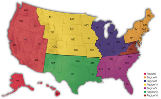
This is a typical map showing different regions in the United States. A region can be a state like Oregon, or can be a piece of the U.S. like the Pacific Region, located on the left hand side. This map could possibly be showing the formal type of a region, as the parts in different colors seem to be in correlation with their location. For example Oregon and California are both the same shade of red because they're located on the pacific coast. We can say that each region here was determind by some type of characteristics that some states either shared or had did not share.